
How to Build Stonehenge comes out on February 17 2022. Published by Thames & Hudson, it has many illustrations (including new photos and diagrams by me) and is the first book to focus exclusively and comprehensively on this theme since Herbert Stone’s The Stones of Stonehenge, published in 1924. There was a lot to say: I’m very excited about it.
When it was finished I put a Stonehenge photo in my Twitter profile, and I changed it every week. Here are their stories, the most recent at the top – all photos taken by me.
***
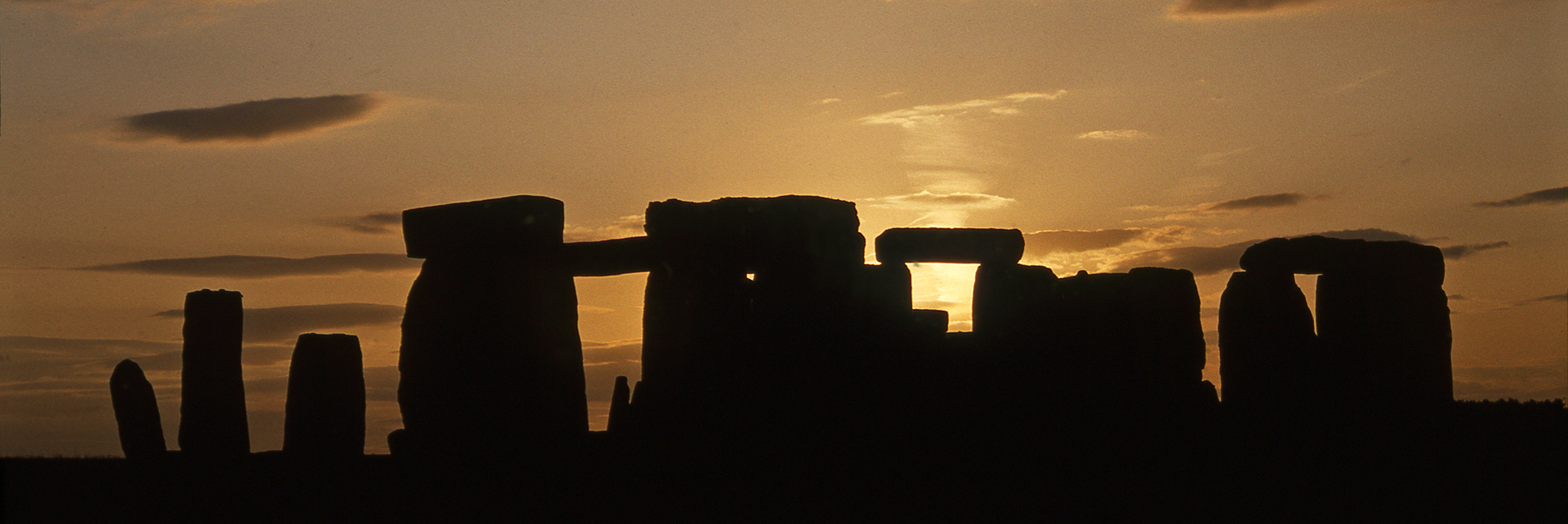
This is the 23rd photo in the series – and the last for now, put into my Twitter header a week before How to Build Stonehenge came out. It’s a pleasant sunset in June 1993: and to be honest I can’t remember why I was there or if there is a story associated with it!

I photographed this slightly disturbing sight on a grey wet day in April 1981. The Department of the Environment which then managed Stonehenge (three years before English Heritage was launched), was building a permanent footpath. With the stones recently fenced off, it would give visitors a chance to get close: it’s where many of us take photos today. It partly followed the route of a long-gone chalk track, but near the stones it would cross ground thought to be undisturbed. Dermot Bond removed the turf where two of the filled-in Y Holes should have been, and found them. It was all a bit odd to me. I had finished my own excavation the year before, where it was clear that earlier archaeologists had underestimated the quality of preservation at the site: ancient remains had been destroyed in the mistaken belief they weren’t there. Yet here we were, most of the path laid without any prior excavation, and a rapid trench dug to look at important known features without actually examining them. With hindsight, I’d say it was probably a good thing the Y Holes were not dug out – we could do that now!

In the early 1980s, when I was curator of the Alexander Keiller Museum in Avebury, my then wife Hilary Howard was working on her PhD with David Peacock at Southampton University. I got to know the road between Wiltshire and the coast well, frequently driving her down before I started work and collecting her in the evening. One weekend we both went down for the day and it snowed heavily, blocking roads across Salisbury Plain. We had to wait until they’d been cleared, so we stayed overnight – handily our vehicle was a VW camper, snowed into the campus carpark. Late the next day we heard a route had been cleared, and off we went… past Stonehenge, offering a rare snow photoshoot with no one else there as the sun turned the sky pink.

Archaeologists had long known that a timber palisade once passed close to Stonehenge, now visible as a line on the ground in air photos. An excavation in 1967, when a pedestrian underpass was built for visitors, revealed that the ditch had once held a continuous line of posts; after they had gone the body of a young man had been buried near the top. Though the burial was dated to the Iron Age, there seemed to be good reason to think the palisade itself was Neolithic. Which was what we expected this trench would show, excavated west of the stones in 2008 by the Stonehenge Riverside Project. It turned out to be not so old, but of great interest – part of a huge Bronze Age enclosure, apparently contemporary with many of the burials in the Stonehenge landscape.

In 2002 I was getting somewhere with freelance journalism and radio, had two books out, and was working on a third I called How to Kill Big Animals, about ice age Europe; in October I’d gone elk hunting in Sweden, and was soon to meet Roger Jacobi in Lancaster to look at the elk remains from Poulton (I never got a contract for the book). However, I’d recently started working as a consultant for what in the event was (another) failed attempt by English Heritage to get planning consent for a new visitor centre, and I was becoming increasingly drawn to Stonehenge. A couple of American acquaintances had flown over with special permission to access the stones for photography at midwinter, and suggested I join them. It was December 19. Management had erected fluorescent orange posts in the centre, holding up a high rope ring. It was there to keep early morning access visitors off muddy turf, which was fair enough, but I felt sorry for my two friends – it could’ve all been taken down during the day, to benefit all visitors. Worse was to come. Sunset was at 4pm. And at 4pm precisely, despite two of us having flown the Atlantic and paid highly in an arrangement planned over months so they could photograph the sunset, we were all ordered off the site… it was closing time.

I earlier posted a photo of a brilliant red-skied midwinter sunset at Stonehenge in 2001. This is sunset 2021 on midwinter day, December 21 – strictly speaking a few minutes before sunset, as the sun finally hid behind a wall of cloud in an otherwise nearly clear sky. A small crowd had gathered behind the Heelstone, 100 beyond the fence, perhaps 300 or 400 inside. The next morning there was a larger crowd, said to be around 1,000, among the stones, the first such public occasion since midsummer 2019 thanks to covid lockdowns. They were privileged to experience a spectacular dawn, in common with much of the country, in a freak sunrise at a time of widespread cloud and mist. As often happens when I visit Stonehenge, I bumped into someone I knew – Julian Richards, filming with an old cameraman friend.
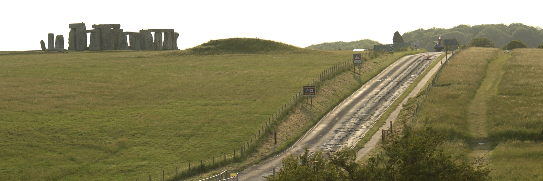
Another view of Stonehenge from the A303 just to the east (see below, third one down). This was taken at a moment of transition in June 2013. The road you can see is the A344, which at this point had just left the A303 and was used mostly by westbound traffic to visit Stonehenge (which was both most of the traffic on the road, and most of the visitors) and stop at the visitor reception just beyond the near horizon on the right. It wasn’t built for Stonehenge, but was a turnpike (private, chargeable) road opened in the 1760s by a local trust to carry traffic westwards to Shrewton and beyond. In the photo you can make out dark lines down the road, which are where the tarmac has been broken up. The road between the A303 and the old visitor centre is now closed and destroyed, the hollow-way filled and the ground seeded to grass.

This is a midwinter sunset, a glorious red sky illuminated by a sun that appeared from beneath the clouds just before it fell beyond the horizon. It’s 2001 on December 30. My plan to be there on midwinter day succumbed to demands of work and I finally made it just before the year end. At this time the sun never rises far into the sky and slowly sets to the south-west, and around the 21st (actual midwinter day) it falls precisely on an alignment through the centre of Stonehenge, the opposite to that experienced at midsummer. I am standing near the Heelstone, with a long-focus lens, looking along that axis. The sun is framed by two stones in the sarsen circle (30 and 1). Beyond it would have been held in a narrower gap between the two stones of the Great Trilithon. The eastern is fallen. The western (Stone 56) can be seen poking its tenon above Stone 30 to the right of the sun. Midsummer day is for a huge crowd. Midwinter is (or at least, was) a much more intimate experience. I was almost alone.

As below, another scene you can no longer see, to the obvious benefit of the landscape and visitors, though before the change occurred, not a few people argued against it. We are looking south towards Stonehenge, visible (just) on the far left, in August 2013, only a few months before the car park closed for good, along with the road leading to it. At these busiest times of year the field north of the paved area was opened up for overflow parking. Now we all park at the visitor centre away from the site to the west (right of this view). On this occasion I was at Stonehenge for some filming with Tony Robinson, in the lovely late afternoon light after the stones had been closed to the wider public.

This is a view of Stonehenge that no longer exists. The traffic in front is still there – in fact there’s more now than there was when I took this photo in October 2007. It’s driving on the A303, which largely due to objectors to plans to bury it in a tunnel, remains a surface road; at the point where I was standing it is a dual carriageway. What’s changed is that the other road, the A344 arcing up the hill to the right, has gone, along with the security fence close to the stones to stop people climbing over, road safety signs and most of the other fencing, The cutting has been filled and the soil grassed, so that the ground now runs evenly across the spur. These works were part of the scheme to remove facilities away from the site to a new visitor centre beyond the horizon, which opened at the end of 2013.

The aftermath of a summer solstice dawn, June 21 2006. It’s 8.30am, everyone’s been up since at least the night before, and is running out of steam. The drummers and Hare Krishna chanters have thankfully gone for their breakfasts, and I’ve just been interviewed by a Channel 5 news team. The police estimated around 20,000 people had come, with little incident; the few arrests made were mostly for traffic offences. Dawn was cloudy and grey, but though you couldn’t really see the sun there was a brief dramatic line of orange on the horizon when it must have been there somewhere, and later it came out for some nice strong light.

A lot of prehistoric cremated human remains were found during excavations at Stonehenge in the 1920s. No museum or archaeologist wanted them, however, and in 1935 the assistant director who had them stored in an attic, and was worried about their fate, engaged the curator of Avebury Museum to bury three sandbags of bones back at the site. When I was researching Hengeworld (2000) I found a file in the national archives which confirmed they were in Aubrey Hole 7. In 2008 I was delighted to be part of a team that excavated that pit – for the third time – to recover the remains for scientific study. Here we are near the start of the dig, with one of two companies that made TV films of the occasion.

At 5am on June 21 1972, Druids celebrate the midsummer solstice in the centre of Stonehenge. At the time I was digging at Mucking in Essex, and a group of us squeezed into my old Mini and drove to Wiltshire for the occasion, spending the brief night of sleep inside the West Kennet long barrow. After the ceremonies were over I talked to participants, bought some little prayer guides from them and watched them, still white-robed, queue up to get back into their coach. It was all very civilised – notwithstanding the coils of barbed wire around the site, which are the blurred lines that cross this image, shot in Kodachrome through the fence beside the Heelstone.

This is a view of the southern part of the sarsen circle looking south-east over the swollen foot of the fallen trilithon Stone 55 (left of centre above dandelions and below the small standing bluestone, Stone 39), the stumpy standing Stone 11 behind and the fallen Stone 14 (the largest right of centre). The tall straight stone near the left of the frame is the other Great Trilithon stone, 56. Circle sarsens in this area seem to have been thinner and less well shaped than those to the north, partly at least leading to more falls and damage and the debated impression that perhaps the circle was never completed at this point. An alternative view (one of several possibilities) is that less impressive stones here emphasised the scale and quality of the Great Trilithon and, across the circle, the impressive north-east facade. I took this photo in May 2012, when I was there with Tom Holland and the Radio 4 Making History programme, talking about Stonehenge visitors.

My original archaeological engagement with Stonehenge was in 1979, opening what became the first of two trenches on the verge of the A344. The road has now gone, but it was very real then. In 1979 we operated from a Southampton University minibus, but in 1980 I had time to organise a shed, and this was the view through its windows – from across the other side of the road. Both digs were unexpectedly productive (in 1979 I had to fight hard against senior opinion that digging there would be pointless). In this case we found an important deposit of stone debris. I have no idea what the bottle of blue liquid is.

This is the top end of Stone 9, on the south-east side of the sarsen circle. The stone fell outwards at some unknown time in the past, and is in two, weathered pieces (this is 9b). In the centre of the photo a rounded bump emerges from the grass. This is the remains of a tenon, a ball that once rose into a hole on the underside of a lintel. Such evidence is important for showing that the circle was once complete, though many stones are now gone. Photographed in July 2012.

This is Foamhenge, created by Crawley Creatures and Darlow Smithson Productions for Channel 5 in 2005. I was the on-screen archaeological consultant. I tell a story about this in How to Build Stonehenge. The full-scale model was made for a low hill a little to the west of the real Stonehenge, not unlike its location. I’d given the modellers a chart of measurements as taken from the actual megaliths (not as easy a thing to assemble as it might sound), so I was puzzled – and Julian Richards was much annoyed! – when our four polystyrene trilithons flanking the great one looked to be much the same height: at Stonehenge they grow taller as they approach the south-west. It was only when examining the recent laser models of the stones that I realised what had happened. Our replica was on flat ground. At Stonehenge, however, the ground rises slightly to the south-west, and its builders had taken account of the subtle variations in topography. They knew what they were doing.

In 1983, when I was curator of Avebury museum, I was asked to monitor the removal of graffiti that had appeared overnight on two stones. POMPEY (the Portsmouth football team) was written on one, and the other had a blue wash. Sand blasting had already begun when I arrived and (rightly or wrongly) it seemed to me that lichen and possibly even sarsen was being removed, so I stopped it at once. I can’t remember how they got the stuff off in the end.

During a hot July in 2013 Simon Banton and Tim Daw, then working for English Heritage, noticed parchmarks in the grass and told archaeologists about them. They revealed features never seen before, including a possible new ring of prehistoric pits, and stoneholes that completed the sarsen circle. The brown area here has never been excavated (as far as we know), and may show a former gravel-paved area.

This is the entrance to the old car park in June 2013, when works were underway to the west to build a new visitor centre. The passing road is the A344, which beyond the signs at the back is being ripped up prior to turfing over.

A more conventional view of Stonehenge, here looking east towards the trees on King Barrow Ridge.

This was at a curious event in October 2006, when someone had (presumably) paid English Heritage to allow them to launch a gas-filled dirigible at the stones to promote their website, to which they (naturally) invited some pagans.

I brought out a Station Stone in this shot with some flash against a sunset, a crop from one of my old Kodachromes.

Hi Mike. The ?gravelled area shows clearly as a lighter patch on Google Earth in 2005 and 2017, when the former pathway is also visible. Earlier years are too blurry but it might be possible to obtain RAF or commercial aerial shots.
“Pompey the Southampton football team”??? Are you deliberately trolling Portsmouth fans?
Just reporting what happened.
Love the cover. Well done on grinding it out. The muse has rather left me at the moment; that said I do bang out several thousand words a week for never-read consultancy reports. Never-read … bit like most of my academic stuff was !
Dr Paul Stamper, FSA
Paul Stamper Heritage
01832 280344 07507 720397
https://paulstamperheritage.wordpress.com
Thanks Paul. You know as an academic that your research will be read by colleagues and a few others. It gets bad though when you sense not even they read it
Reblogged this on Stonehenge Stone Circle News and Information and commented:
How to Build Stonehenge by Mike Pitts. Draws on a lifetime’s study and a decade of new research to address the first question that every visitor asks: how was Stonehenge built?
I think you’ve missed the point here, Mike. Pompey is the nickname for the Portsmouth football team, not Southampton (the “Saints”). Saints fans (like me) would never do anything so disrespectful 🙂
God you’re right, Mike, apologies all round and corrected!
For your interest your first section at top concerning winter solstice is far more relevant than you may realise. The main S.H. axis is exactly summer solstice one-way, and winter the other. Obviously this is not accidental. You must look beyond our local sun, moon solar system.
Astronomically the VERY SIMPLE POINT is that any Cosmic sky we may see from a fixed site is exactly identical throughout the year EXCEPT FOR THE TIME OF RISING. The sky that rises exactly with the sun at mid-summer dawn will rise and be EXACTLY THE SAME at midwinter BUT TWELVE HOURS LATER, i.e. at darkness. If we could mark an important STELLAR rising (not SOLAR or LUNAR), for instance, as being north-east with sunrise at mid-summer (4 a.m.), we could mark that very same rising at mid-winter with setting sun (4 p.m.) when the sun sets south-west, BUT THE STELLAR OBJECT WILL STILL RISE AT THE SAME NORTH EAST POINT. Only providing that we can build our viewing point at the correct latitude, then we can achieve this property of having everything happen diametrically opposite as it does along the Stonehenge Axis.. THIS IS THE WHOLE POINT of the layout and construction of Stonehenge as was.
If it sounds complicated you need to think about this layout for about three minutes and it can be seen to be very, very simple in practise. Astonishingly simple, precise, accurate, economical, monumental.
You may say that this concept was too advanced for ‘primitive’ minds. How do you know what their brains could achieve – just look at their building skills! And we can be confident that they were observing the cosmic sky for centuries, or even millennia, before Sarsen Stonehenge.
You may object that stellar objects are not visible close to the horizon due to our atmosphere. You would be correct. O.K. lets put up an artificial horizon so that we actually CAN see the stellar object when it IS visible. (We’ll call our artificial horizon ‘LINTELS’.) (For the interest the arc of horizon encompassed (from Great Trilithon arch) between Main Axis and ‘Entrance’ to Bluestone and Trilithon Horseshoes comfortably accommodates the poorly visible section of a cosmic object’s rising trajectory from horizon to higher and more visible altitude. Said cosmic object would appear above the lintels just before it rose past the north-east ends of the Horseshoes. Maybe just another coincidence!)
Stonehenge, its size. complexity, and sheer physicality are enormous. It follows that the motivation, to the builders, was equally monumental. If you wish to understand what they were seeing and why, then you must look with their eyes beyond our little local solar system and out to the cosmos. It is very very easy. It just needs the step forward from local archaeological mindset to expansive astronomical – easy! Neolithic eyes.! Neolithic vision!
Mike
Any thoughts on para 1 ?; I don’t think you managed to reply.
Thanks, and best wishes
Paul
Dr Paul Stamper, FSA
Paul Stamper Heritage
01832 280344 07507 720397
https://paulstamperheritage.wordpress.com